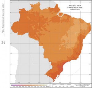
In 2006, the Brazilian Atlas for Solar Energy presented a survey on the availability of solar energy in Brazil, using an incentive transfer model fed by climatology data and information collected for 10 years from geostationary satellite images and validated by data collected at surface stations.
The mapping of the solar energy potential presented in this document was one of the products generated by the SWERA Project (Solar and Wind Energy Resource Assessment), funded by the United Nations Environment Program (UNEP) and co-funded by the Global Environment Fund (GEF).
The project, which started in 2001 under the management of the Department of Climate and Environmental Affairs of the Center for Weather Forecast and Climate Studies at the National Institute for Space Research (DMA/CPTEC/INPE), focuses mainly on building a reliable, high-quality database to assist in planning and developing public policies to encourage nationwide solar and wind energy projects, and attract private sector investments in the area of renewable energy.
The resulting database is compatible with geographic information systems (GIS) and, therefore, can be easily used in economic feasibility studies for project development purposes.
Solar energy products aimed at Brazil were developed through a partnership between DMA/CPTEC/INPE and the Solar Energy Laboratory from the Federal University of Santa Catarina (LABSOLAR / UFSC), using the radiative transfer model BRAZIL-SR and a geo-referenced database of environmental and socioeconomic data freely provided by several national and international partners.
“Brazil has a particularly advantage for this type of application (grid-connected PV systems in urban areas) because of the considerable amount of solar energy available and the high value that PV systems can be given in business centers in urban areas”, explain the authors of the Atlas.
Other studies of the SWERA project can be found at SONDA – National Organization System of Environmental Data.
El Atlas Brasileño de Energía Solar presentó en 2006 un levantamiento de la disponibilidad de energía solar en el territorio brasileiro, utilizando un modelo de transferencia radiactiva alimentado por datos climatológicos y por 10 años de informaciones extraídas de imágenes de satélite geoestacionario y validado por datos recogidos en estaciones de superficie.


Leave a Reply
Want to join the discussion?Feel free to contribute!